An inland county of the province of Ulster, is bounded, on the north, by Derry; on the east, by Lough Neagh (separating it from Armagh); on the south, by Armagh and Monaghan; and on the west, by Donegal and Fermanagh. Its greatest length, from north-east to south-west, is about 55 miles; its greatest breadth, from east to west, is about 38 miles; and its area is 806,640 statute acres, or about 1,260 square miles, of which about 450,826 acres are arable or under cultivation, 311,867 acres are bog and mountain (including extensive tracts of moorland and unreclaimed bog), 20,000 woodland, and the rest towns, villages, roads, and water (including a portion of Lough Neagh).
POPULATION, In 1831, 302,836; in 1841, 312,956, showing an increase of 10,120, or about 3.3 per cent. Houses in 1841, 52,614. Families chiefly employed in agriculture, 40,614; in manufactures and trade, 6,614; in other pursuits, 5,386. Families dependent chiefly on property and professions, 2,000; on the direction of labour, 12,614; on their own manual labour, 35,614; on means not specified, small number.
The county is divided into 8 baronies: Clogher, Dungannon Lower, Dungannon Middle, Dungannon Upper, Omagh East, Omagh West, Strabane Lower, and Strabane Upper. It contains 74 civil parishes, and parts of others; about 2,200 townlands. Poor Law Unions: Armagh (part), Castlederg, Clogher, Cookstown, Dungannon, Gortin, Irvinestown (part), Limavady (part), Omagh, Strabane. The Poor-Law valuation is about £300,000 to £350,000.
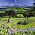
SURFACE AND TOPOGRAPHY, The surface is diversified: the east is level or gently undulating along Lough Neagh, with fertile plains and valleys; the centre and west are hilly and mountainous, with the Sperrin Mountains (rising to 2,240 feet in Sawel, the highest point), Bessy Bell, Mullaghcarn, and other ranges; the north-west is rugged with glens and moors. Mean elevation about 400-600 feet above sea-level. Bogs extensive in low tracts (reclaimable with drainage and liming); limestone in east and parts of centre (good for manure); sandstone, slate, quartz in mountains; scenery picturesque in hilly districts with glens, lakes, and river views.
RIVERS AND LAKES, The chief river is the Blackwater (forms part of eastern boundary, navigable in lower parts, flows into Lough Neagh). Principal others: Mourne (formed by junction of Derg and Strule, flows to Foyle); Strule (from Omagh); Derg (from Lough Derg); Owenkillew, Drumragh, Camowen, Foyle (boundary), Ballinderry (to Lough Neagh), etc. Lakes: Lough Neagh (portion in east, large); Lough Catherine, Lough Macrory, Lough Braden, Lough Derg (sacred, pilgrimages), small mountain loughs. Fisheries moderate (salmon in rivers, eel in Lough Neagh).
SOIL AND AGRICULTURE, The soil varies: rich loam and clay in east and valleys (good for oats, barley, potatoes, flax); lighter gravelly or sandy in hills; moorish and rocky in mountains; bogs improvable. Limestone districts fertile with marl. Crops: oats (chief), barley, potatoes extensive, flax (important, linen trade), wheat limited. Pasture supports cattle, sheep; dairy produce fair. Tillage improving with liming, rotation; farms small to medium; husbandry advanced in lowlands, backward in mountains.
CLIMATE, Mild, moist; rainfall heavy from Atlantic and mountain influence; salubrious though damp in low districts.
MINERALS, Limestone abundant in east; sandstone, slate (quarried); coal (bituminous, worked at Coal Island, Dungannon); iron ore (traces); lead, silver (limited); peat extensive in bogs.
TRADE AND MANUFACTURES, Chiefly agricultural and linen; trade at Dungannon, Omagh, Strabane (linen, grain, butter, cattle to Belfast/Dublin/Liverpool). Manufactures: linen (extensive, coarse and fine), brewing, distilling.
TOWNS, Dungannon (county town, market and assize, pop. about 4,000-5,000); Omagh (pop. about 4,000); Strabane (border town, pop. about 5,000); Cookstown (pop. about 3,500); Clogher (ancient see, pop. small); Castlederg, Aughnacloy, Stewartstown, Moy, Caledon, etc.
ECCLESIASTICAL, Diocese of Armagh (province of Armagh; portions); Clogher (ancient, cathedral at Clogher); Derry (parts). Roman Catholic dioceses of Armagh, Clogher, Derry; numerous chapels. Protestant churches in towns. Tithes commuted.
ANTIQUITIES, Numerous: castles (Dungannon, Benburb site of battle 1646); ecclesiastical ruins (Clogher cathedral, Donaghmore round tower and cross); forts, raths, crannogs in Lough Neagh; ancient churches; high crosses; cairns in mountains; sacred sites (Lough Derg pilgrimages).
Ireland in 1846
Antrim – Armagh – Carlow – Cavan – Clare – Cork – Derry – Donegal – Down – Dublin – Fermanagh – Galway – Kerry – Kildare – Kilkenny – Laois – Leitrim – Limerick – Longford – Louth – Mayo – Meath – Monaghan – Offaly – Roscommon – Sligo – Tipperary – Tyrone – Waterford – Westmeath – Wexford – Wicklow
County Tyrone:
Ireland’s county Tyrone is a county of rolling landscapes and historic sites, with the Ulster American Folk Park in Omagh offering a fascinating look at emigration history through recreated villages. The Sperrin Mountains provide hiking trails with panoramic views, while the Beaghmore Stone Circles add ancient intrigue. Other attractions include the historic town of Dungannon and its castle ruins. Tyrone is Ireland’s seventh largest county by size (3,263 square km) and 11th largest by population (188,383). Population peaked at 312,956 in 1841 and reached its lowest point, 127,586 in 1936. In terms of hospitality, Tyrone is Ireland’s 24th most visited tourist county with around 68,000 international visitors per year.
Introduction – Adventure – Anthem – Archaeology – Attractions – Awards – Birdwatching – Camping – Castles – Churches – Contact list – Cycling – Dining – Equestrian – Festivals – Fishing – Folklore – Gardens – Golf – Graveyards – Happening – Haunted – Highest – Hiking – History – Holy Wells – Hotels – Hotels top 8 – Hunting & shooting – Instagrammable – Itineraries – Largest town – Luxury – MICE – Movies – Music – Name – New – Novelists – Off the beaten track – Poets – Pubs – Quotes – Random Facts – Restaurant Awards – Sacred Places – Saints – Songs – Spas – Sports – Sunsets – Sustainable – Things to do – Towns – Video – Villages – Walking – Wanderlist – Weddings – Wild swimming – Writers – 1837 – 1846– 1852 – 1909 – 1955 – 1980 –