
A maritime county of the province of Leinster, is bounded, on the north, by Armagh and Monaghan; on the east, by the Irish Sea; on the south, by Meath; and on the west, by Meath, Cavan, and Monaghan. Its greatest length, from north to south, is about 32 miles; its greatest breadth, from east to west, is about 20 miles; and its area is 201,828 statute acres, or about 315 square miles, of which about 160,000 acres are arable or under cultivation, 30,000 bog and waste, 5,000 woodland, and the rest towns, villages, roads, and water (including portions of bays and estuaries).
POPULATION, In 1831, 108,240; in 1841, 123,190, showing an increase of 14,950, or about 13.8 per cent. Houses in 1841, 20,614. Families chiefly employed in agriculture, 15,614; in manufactures and trade, 3,614; in other pursuits, 1,386. Families dependent chiefly on property and professions, 1,000; on the direction of labour, 6,614; on their own manual labour, 12,614; on means not specified, small number.
The county is divided into 4 baronies: Ardee, Drogheda, Dundalk Lower, and Dundalk Upper (with Ferrard sometimes noted in boundary overlaps but primarily in Meath). It contains 64 civil parishes, and parts of others; about 1,000 townlands. Poor Law Unions: Ardee, Drogheda, Dundalk. The Poor-Law valuation is about £150,000 to £180,000.
SURFACE AND TOPOGRAPHY, The surface is chiefly level or gently undulating champaign, part of the great eastern limestone plain; diversified with low hills, ridges, and shallow valleys; mean elevation about 200 feet above sea-level. The north-east is more elevated with the Carlingford Mountains (rising to 1,000–1,385 feet in Slieve Foy or other peaks), Cooley Peninsula hills; the centre and south are fertile plains; bogs occur in low tracts (reclaimable); limestone prevails, with fertile soil in valleys; picturesque coast scenery with wooded hills and glens.
RIVERS AND BAYS, The chief rivers are the Boyne (forms southern boundary in part, navigable to Drogheda and beyond); the Dee (flows through centre to Dundalk Bay); the Glyde (northern districts, to Dundalk Bay); the Fane (northern, to Carlingford Lough); the Castletown (to Dundalk); smaller streams: Mattock, Whitewater, etc. Bays: Dundalk Bay (large, shallow, with harbour), Carlingford Lough (excellent sheltered inlet, shared with Down). Fisheries valuable (herring, cod, haddock).
SOIL AND AGRICULTURE, The soil is generally fertile: rich deep loam and clay in valleys and east (excellent for wheat, barley, oats); gravelly loam in hills; lighter in parts. Limestone abundant for manure. Crops: wheat (noted quality), barley, oats (chief), potatoes, turnips (increasing). Pasture supports dairy cattle (butter high quality), sheep. Tillage improving with liming, rotation; farms small to medium; husbandry advanced near coast and towns, backward in hilly districts.
CLIMATE, Mild, moist, equable; influenced by sea; rainfall moderate to heavy; salubrious, tempered by proximity to Irish Sea.
MINERALS, Limestone chief (building stone, manure); sandstone, slate; some coal traces (not worked); no extensive metals.
TRADE AND MANUFACTURES, Chiefly agricultural; trade at Drogheda and Dundalk (grain, butter, cattle, provisions to Dublin/Liverpool); imports coal, timber. Manufactures limited: linen, brewing, distilling, milling in towns.
TOWNS, Dundalk (county town, seaport, pop. about 10,000); Drogheda (large borough and port, pop. about 12,000); Ardee (market town, pop. about 3,500); Carlingford (small port, pop. about 1,500); Dunleer, Collon, Castlebellingham, Termonfeckin, etc.
ECCLESIASTICAL, Diocese of Armagh (province of Armagh; cathedral at Armagh, but Louth has portions); parts in Meath. Roman Catholic diocese of Armagh; numerous chapels. Protestant churches in towns. Tithes commuted.
ANTIQUITIES, Numerous and important: round tower and high crosses at Monasterboice (finest examples); Mellifont Abbey ruins (Cistercian, founded 1142); castles at Carlingford, Dundalk, Ardee, Drogheda (Norman origins); abbeys at Newtown, Clonmore; raths, forts, cromlechs, ancient churches; battle sites (e.g, Boyne influences nearby).
Ireland in 1846
Antrim – Armagh – Carlow – Cavan – Clare – Cork – Derry – Donegal – Down – Dublin – Fermanagh – Galway – Kerry – Kildare – Kilkenny – Laois – Leitrim – Limerick – Longford – Louth – Mayo – Meath – Monaghan – Offaly – Roscommon – Sligo – Tipperary – Tyrone – Waterford – Westmeath – Wexford – Wicklow
County Louth:
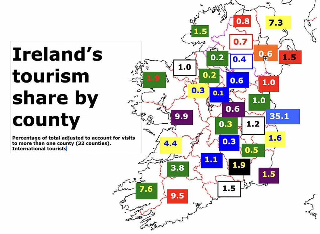
Ireland’s county Louth is a county of historic depth and coastal beauty, with Drogheda’s St Peter’s Church housing a historic shrine and the Boyne Valley offering ancient sites like Newgrange, a UNESCO-listed passage tomb just over the border in county Meath. Carlingford’s medieval streets and castle provide scenic walks, while Dundalk’s coastal paths add natural allure. Other attractions include the Cooley Peninsula’s hiking trails. Louth is Ireland’s smallest county by size (821 sq km) and 17th largest by population (139,703). Population peaked at 128,240 in 1841 and reached its lowest point, 63,665 in 1926. In terms of hospitality, Louth is Ireland’s 21st most visited tourist county with around 108,000 international visitors per year.
Introduction – Adventure – Anthem – Archaeology – Attractions – Awards – Birdwatching – Camping – Castles – Churches – Contact list – Cycling – Dining – Equestrian – Festivals – Fishing – Folklore – Gardens – Golf – Graveyards – Happening – Haunted – Highest – Hiking – History – Holy Wells – Hotels – Hotels top 8 – Hunting & shooting – Instagrammable – Itineraries – Largest town – Luxury – MICE – Movies – Music – Name – New – Novelists – Off the beaten track – Poets – Pubs – Quotes – Random Facts – Restaurant Awards – Sacred Places – Saints – Songs – Spas – Sports – Sunsets – Sustainable – Things to do – Towns – Video – Villages – Walking – Wanderlist – Weddings – Wild swimming – Writers – 1837 – 1846 – 1852 – 1909 – 1955 – 1980 –

")
